


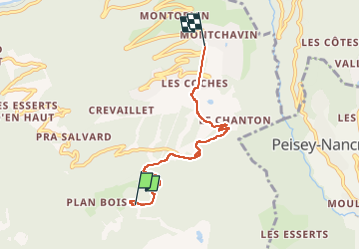
230113 PlanBois

randodan
User

Length
4.8 km

Max alt
1882 m

Uphill gradient
13 m
Km-Effort
7.1 km

Min alt
1245 m

Downhill gradient
630 m
Boucle
No
Creation date :
2023-01-12 12:48:22.077
Updated on :
2023-01-12 14:50:00.325
2h01
Difficulty : Medium

FREE GPS app for hiking
 SityTrail
IGN / Geographical institutes
SityTrail Plus
The world is yours!
About
Trail Walking of 4.8 km to be discovered at Auvergne-Rhône-Alpes, Savoy, La Plagne-Tarentaise. This trail is proposed by randodan.
Description
resto
Positioning
Country:
France
Region :
Auvergne-Rhône-Alpes
Department/Province :
Savoy
Municipality :
La Plagne-Tarentaise
Location:
Bellentre
Start:(Dec)
Start:(UTM)
322172 ; 5045404 (32T) N.
Comments